Materuni Waterfall Day Tour

Materuni Waterfall Day Tour

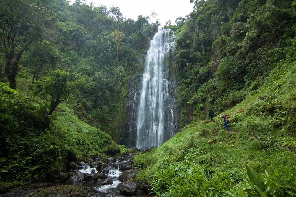
Materuni Waterfall is a booming waterfall just 15- kilometers from Moshi Town. When combined Materuni waterfall with a coffee tour in the village, it makes for a perfect day trip before or after your Mount Kilimanjaro climb. With about eight kilometers of walking throughout the day and 300 meters of incline, this materuni waterfall tour adventure is a great warm-up for the legs while also getting to immerse yourself in the local culture. The materuni waterfall tour begins by observing the entire process of making a cup of coffee, from seed to mug. After a locally produced lunch, you head off to explore the massive Materuni Waterfall.

The materuni waterfall day trip tour begins by passing through coffee and banana plantation. Chance of meeting a variety of primates including Black and white Colobus monkeys. Explanation about local people/life and tradition of Chagga people

Enjoying the nature of the slopes of Mount Kilimanjaro Explanation of different flowers

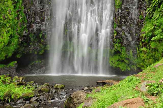
Visit the waterfalls, get explanation and enjoy swimming if you like to. Hiking up to the boundary of Mount Kilimanjaro national park 2400m.You will learn how to make local coffee and drink your own made coffee. The best view point for the snow peak of Mt. Kilimanjaro if not covered by clouds

But that’s not all. Next the coffee experience awaits you. Here you will learn how coffee is cultivated, dried, roasted and further processed. You will also be invited to help with the grinding of the coffee, which is traditionally accompanied by Chagga songs and dances – a fun way to immerse yourself in the local culture.

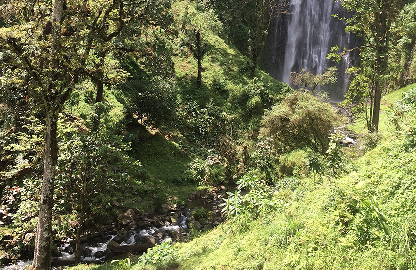
Before you say goodbye and return in the afternoon to Moshi, you can savour the coffee you made and appreciate the views of the surrounding rainforest.

Apart from Materuni waterfall tour clients can opt doing marangu waterfall day trip tour, or Makoa animal farm tour or Kikuletwa hot spring 

Welcome to Materuni waterfalls.

PRICES AND SERVICES                     

Prices depend on the size of your group and are as follows:

1 person: 120 USD per person

2 people: 70 USD per person

3 people: 60 USD per person

4- people onwards: 50 USD per person.

Please contact us for different group sizes or groups including children. All our day trips can depart from another starting point, like the airport for example. Prices might be different in this case, so please let us know and we’ll send you the right quote.

What's included:

  • A bottle of water per person (1,5 liters)
  • Entrance fee to the village and waterfall
  • Coffee tour and tasting
  • Chagga lunch
  • Private transport from your accommodation in Moshi to Materuni village and back
  • English speaking guide that will guide you from Materuni village to the waterfall and teach you about Chagga culture

This Materui tour, a tip is expected after your participation in a tourist activity. This tip is not included in your package. The recommended amount for a tour guide is 25-30 USD per day if you’re satisfied, to be divided by all your group members. As we pay a lot of attention to creating good working conditions for all our crew members and making sure they get paid according to guidelines from organizations that defend their rights, we kindly request you to respect this amount for any trip. Thank you! 

So, not sure what to do in Moshi in the next couple of days? Send us a message and we’ll make sure you have an amazing time!

ENQUIRE ABOUT THIS TOUR

    Useful Information

    YOU MIGHT ALSO LIKE

    Where to Stay in Ngorongoro

    Where to Stay in Ngorongoro

    There are five lodges in Ngorongoro Conservation Area built on the rim of the crater, and one lodge in Ndutu area. These facilities include old classic lodges built in the colonial days and new establishment built in the 1990s. There are other modern lodges, hotels, and guesthouses outside the Conservation Area, especially in and around Karatu, that are especially suitable for visitors planning day trips or those looking for budget accommodation.

    Within the Ngorongoro Conservation Area, with the exception of Simba ‘A’ public campsite near the NCAA headquarters, the campsites are all classified as “special campsites”. This means that they are for exclusive use, and generally have no facilities. Usually they are designed for self-sufficient safari operations, which bring everything with them. Most are large sites, but a few of them, e.g. on the rim of Empakaai Crater, are designed for small numbers of back – packers. Camping generally is not allowed in the Crater itself. Book campsites through the NCAA headquarters’ office or in Arusha – Ngorongoro Information Center.

    There are luxury lodges situated within and outside the Ngorongoro Conservation Area. Names and contacts of those lodges within the Conservation Area are:

    Our Migration Safaris

    Useful Information

    Olmoti Crater

    Olmoti Crater

    Olmoti Crater is to the North of Ngorongoro Crater and south of Empakaai Crater. The floor of Olmoti is shallow and grassy, and it is the source of the Munge River, which feeds the Ngorongoro Crater.

    Though not as famous as Ngorongoro and Empakaai, Olmoti Crater is worth visiting when travelling North into the highlands. Trekkers can start a two-day walking safari from Olmoti to Empakaai.

    It is also possible to climb to the rim and descend down the floor of Olmoti. The highest point at Olmoti is 3,080m and the crater is about 6.5km in diameter. There is a short trail that leads to the Munge Waterfall. Beware of dangerous games along the way and visitor should be accompanied by an armed ranger.

    Our Migration Safaris

    Useful Information

    The Maasai of Ngorongoro

    The Maasai of Ngorongoro

    In addition to the beautiful scenery, archaeological wealth and abundant wildlife, Ngorongoro Conservation Area is also blessed with a proud people – the Maasai – a pastoral tribe that has maintained their traditional culture a great deal.

    Before the Maasai, there were other tribes that also occupied Ngorongoro, some as cattle herders, like the Datoga, and others as hunters, like the Hadzabe; and then moved on, sometimes forced out by other groups.

    The Maasai colonized the area in substantial numbers, their traditional way of life allowing them to live in harmony with the wildlife and the environment. Approximately 100,000 Maasai live in the conservation area today tending their livestock without harming wildlife.

    Visitors to the Ngorongoro Conservation Area can learn about the culture of the Maasai and take photographs or buy original Maasai handicraft at designated areas known as cultural bomas. In order to safeguard the livelihood of these people and at the same time conserve the flora and fauna of the area, Ngorongoro Conservation Area Authority supports and initiates community-based projects, such as ecotourism in the form of these cultural bomas.

    In partnership with the Maasai council known as Ngorongoro Pastoral Council, the Ngorongoro Conservation Area Authority oversees the progress of these cultural bomas, and also enables Maasai guides to conduct walking safaris and other part-time work at the lodges and at the headquarters of the Conservation Area.

    Our Migration Safaris

    Useful Information

    Ngorongoro Crater

    Ngorongoro Crater

    Ngorongoro Crater is the world’s largest intact and unfilled volcanic caldera, and is indeed the flagship tourism attraction of the Ngorongoro Conservation Area.

    Measuring an area of 260 square kilometers and extending about 20km in diameter, the crater is actually a huge caldera of a volcano that collapsed to a depth of 610m about three million years ago. Over the course of time, streams of water made their way down the crater to form little ponds, and vegetation developed all over, attracting a wide range of wild animals. The crater is host to over 25,000 animals including populations of large mammals such as elephants, buffaloes, elands, wildebeests, zebras, gazelles, hippos, and rhinos, as well as such carnivores as lions, hyenas, jackals, and cheetahs. The ponds, or rather small lakes on the floor of the crater also host a wide-range of water birds including flamingoes and pelicans. Away from the crater floor, the forests on the crater rim is home to leopards, reedbuck, warthogs, and forest birds to complete a natural zoo, and Africa’s ultimate destination to see the “Big Five” (lion, elephant, rhino, leopard and buffalo).

    Ngorongoro Tourism

    From the misty mountains and lush forests to the sweeping grasslands with their teeming herds. Ngorongoro provides a rich adventure to every visitor. Part of the fees that you pay help the NCAA to carry out its many projects and duties and improve roads and other facilities and services. But a large part also goes to the central government to help support the country as a whole. NCA and the National Parks are the important earners of foreign exchange for Tanzania. The Ngorongoro Conservation Area Authority want you to enjoy Ngorongoro’s outstanding wildlife and scenery. You can help by respecting their rules. Please do what you can do to help protect this wonderful land, its wildlife and people.

    When to Visit /Time to Visit Ngorongoro

    The Ngorongoro Conservation Area is a destination for wildlife viewing that can be visited at any time of the year. Unlike on the plains, where the numbers of animals is dictated by the availability of food and water, abundant game is present inside the crater year round because food and water are always available for both herbivores and predators.

    Outside the crater, but still in the conservation area, from around December to May (depending on the rains), over one million wildebeests and thousands of zebras and gazelles move south to calve in the short-grass plains around Ndutu that straddle the conservation area and Serengeti National Park. This is the area where the animals regroup to start the annual wildebeest migration that spans through the Serengeti ecosystem.

    For birders, the period from November to March is the best time to see migrant bird species, in addition to the indigenous species. Botanists will enjoy most the wet season, which runs from March to early June.

    Our Migration Safaris

    Useful Information

    The Wildlife of Ngorongoro

    The Wildlife of Ngorongoro

    There have been 115 species of mammal recorded in the Ngorongoro Conservation Area. The two main areas for game-viewing, apart from the crater, are the short-grass plains west of the Gol Mountains, northwest of Ngorongoro Crater, and the surroundings of Lake Ndutu close to the border with Serengeti National Park.The two areas become the feeding and breeding ground for over 2 million animals during the rainy reason as they support the great annual wildebeest migration that spans the Serengeti ecosystem. From around December to May (depending on the rains), over one million wildebeests and thousands of zebras and gazelles move south to calve in the short-grass plains around Ndutu that straddle the Conservation Area and Serengeti National Park.

    Elephants, elands, hartebeests, and the endangered rhinos are among the residents of the crater. There are also resident zebras and wildebeests in the crater that do not take part in the annual migration. Hippos are found in the permanent fresh water pools and the swamps in the crater. Other non-migratory herbivorous mammals that are found in the Conservation Area include buffalos, waterbucks, warthogs, and kudus and other species of antelope. Giraffes live in the surroundings of Lake Ndutu, where acacia trees are abundant.

    The carnivores found in the Ngorongoro Conservation Area include lions, cheetahs, hyenas, leopards, jackals, serval cats, and the endangered wild hunting dogs.

    There are over 550 recorded species of birds in the Conservation Area, of which some are resident and others are migratory. Lake Magadi, a salt lake on the floor of the crater, is often inhabited by thousands of lesser flamingos and other water birds. These birds can also be observed around Lake Ndutu and in the Empakaai Crater Lake.

    The forests of Ngorongoro are also abundant with birds, including species of turaco and hornbill. Raptors such as the goshawk and harrier are common on the plains of the Conservation Area.

    Our Migration Safaris

    Useful Information

    Ngorongoro Attractions

    Ngorongoro Attractions

    Shifting Sand in Ngorongoro

    North of Olduvai Gorge on the plains is a spectacular moving ash dune, famously known as Shifting Sands. It is a remarkable crescent-shaped, black dune, composed of volcanic ash from the active Oldonyo Lengai, reaching about 9 meters high and stretching about 100 meters at the curves. The dune is being blown slowly westward across the plains, at the rate of about 17 metres per year.

    Gol Mountains

    The Gol Mountains lie in the remote northern end of the Ngorongoro Conservation Area, rising from the open short-grass plains to a height of 915m. The mountains are a series of ridges described by geologists as some of the oldest geological formations in the area: they were formed millions of years before the formation of Ngorongoro Crater. The surroundings of the Gol Mountains are lush green during the rainy season, from March to early June, hosting thousands of herbivores, and in the next dry months, the vegetation turns dusty brown.

    Olkarien Gorge

    The Olkarien Gorge (also written Ol Karien) is famous as a vital nesting site of the Ruppell’s Griffon Vulture. It is a place to see vultures soaring, circling and gliding down to their nests. The best time to visit the gorge is from March to April when the vultures are breeding. The Olkarien Gorge is located in the northern end of Ngorongoro Conservation Area, just below the border with Loliondo Open Game Controlled Area, and to the east of the Gol Mountains. The gorge is deep and narrow and extends to a length of 8km.

    Lake Ndutu and Lake Masek

    Lake Ndutu and Lake Masek are close to the border with Serengeti National Park on the western side of Ngorongoro Conservation Area. The two lakes form shallow basins where water accumulates from the nearby areas of slightly higher altitude. The water in both lakes is extremely saline, and most of it evaporates during the dry season The area around the lakes is the staging ground and take off point for the migration because it is surrounded by woodlands and the short grass plains, which provide ample cover and food.

    Mounts Lolmalasin and Losirua

    Mount Lolmalasin is the highest crater mountain in the Ngorongoro Conservation Area, and indeed, it is the third tallest mountain in Tanzania, reaching a height of 3,700m above sea level. Attached to Lolmalasin, but rising as an independent mountain, is Mount Losirua (3,260m). The two mountains are located near the eastern border of the Conservation Area, opposite the Olmoti Crater on the way to Empakaai Crater. Mount Lolmalasin can be climbed by first driving to the Maasai villages of Olturotowas or Nainokanoka near their base, and hiking from there towards its peak. Climbing the mountain normally requires a game ranger, and the whole trip takes a day. The peak of Lolmalasin provides attractive views of the surrounding features of the conservation area.

    Our Migration Safaris

    Useful Information

    Getting to Ngorongoro

    Getting to Ngorongoro

    Most visitors approach the Ngorongoro Conservation Area from the town of Arusha, about 180 kilometres away. The road from Arusha to Ngorongoro Conservation Area is good and is paved; it enters the Conservation Area through the Loduare Gate near the town of Karatu.

    Another common entry point is from the west, from Serengeti National Park, on a gravel road through Naabi Hill Gate. It is also possible to get to Ngorongoro Conservation Area by flying a charter plane. There is an airstrip on the crater rim, close to the headquarters of Ngorongoro Conservation Area.Other local airlines have scheduled flights from Arusha, and other major destinations in the country to Serengeti next door, which makes easy connection to Ngorongoro.

    Game-viewing safaris around Ngorongoro Conservation Area, and particularly entry into Ngorongoro Crater, are restricted to four-wheel-drive vehicles (4WD) only.

    There are various tour companies that offer safari service to Ngorongoro Conservation Area and other wildlife areas in northern Tanzania, usually as part of a tour package. For visitors who have no experience of African travel, an organized tour is highly recommended. Details of tour companies that can arrange your safari can be obtained from a travel agent, or from the Tanzania Tourist Board, or from the Tanzania Confederation of Tourism. Most tour companies offer full packages that include transport, entry fees, accommodation, and transfers from airports.

    Our Migration Safaris

    Useful Information

    Empakaai Crater

    Empakaai Crater

    Empakaai Crater may not be as famous as Ngorongoro, but many travellers consider it to be its match in beauty. Empakaai is about 8km in diameter, and holds a beautiful; round lake that occupies nearly half its floor. The lake draws flamingos and other water birds and is surrounded by steep-sided, forested cliffs at least 300m high. When flamingos are there, from the rim it looks like pink beaches around the lake.

    On the outside, the elevation of Empakaai on the western side is 3,200m above sea level and on the eastern side, 2,590m above sea level. Because of this high altitude Empakaai is almost always shrouded in mist, and the lake appears emerald or deep blue in colour.

    Visitors to Empakaai can walk to the rim to catch the appealing scenery or hike down into the crater. From the rim, visitors can view the volcanic cone of Oldonyo Lengai to the northeast, and even the alkaline Lake Natron shimmering in the distance.

    A trail descends from the rim to the floor of the crater through the mountain forest hosting birds and monkeys.

    The descent to the bottom of the crater takes between 30 and 50 minutes, and might take twice that time to climb back up. Visitors hiking down Empakaai are required to be accompanied by an armed ranger. There are special campsites on the rim of Empaka crater available in booking in advance. Campers at Empakai should bring their own drinking water as well as camping gears.

    Rangeland – Ngorongoro

    Ngorongoro is home to lush green, rain-watered vegetation, as well as desert plants. The area has uncultivated lowland vegetation, arid and semi-arid plant communities, abundant short grass used for grazing, and highland forests.

    Scrub heath, grasslands, high open moorland, and the remains of dense evergreen forests cover the steep slopes of the crater, while highland trees including Peacock Flower, Yellow-Wood, Kousso (Hagenia abyssinica), and Sweet Olive can also be found. There are also extensive stretches of pure bamboo on Oldeani Mountain, and Pencil Cedar on Makarut Mountain to the west. Dove- weeds dominate the lower slopes, while the upland woodlands contain Red Thorn Acacia and Gum Acacia that are critical for protecting the watershed.

    The crater basin is covered by open short grass plains with fresh and brackish water lakes, marshes, swamps, and two patches of Acacia woodland. The Lerai Forest is home to the acacia or Yellow Fever tree while Laiyanai Forest has Pillar Wood and Acacia Lahai. The undulating plains to the west are grass-covered with occasional Umbrella Acacia and Commiphora Africana trees. Blackthorn Acacia and Zebra wood dominate in the drier conditions beside Lake Eyasi. These extensive grasslands and bush are rich, relatively untouched by cultivation, and support very large animal populations.

    Our Migration Safaris

    Useful Information

    The Archaeological Sites of Ngorongoro

    The Archaeological Sites of Ngorongoro

    Laetoli Footprints

    The Laetoli Footprints are the oldest known footprints of early ancestors of humans in the world. The site of Laetoli is 25 miles to the southwest of Olduvai Gorge in the Conservation Area. About 3.6 million years ago in Laetoli, two early ancestors of humans walked through wet volcanic ash. When the nearby volcano erupted again, subsequent layers of ash covered and preserved the oldest footprints of early humans.

    According to archaeologists, the Laetoli Footprints present three separate tracks of an upright walking hominid named Australopithecus afarensis. The entire footprint trail is almost 27 meters long and includes impressions of about 70 early human footprints. Replicas of these footprints are displayed at Olduvai Museum.

    The Laetoli area was first studied by the German entomologist Kohl Larsen in the 1920s and yielded a few fossils. In 1974 a team led by Mary Leakey made the discoveries of the hominid footprints, and excavations were carried out in 1978 and 1979.

    Nasera Rock

    Nasera Rock is a huge monolith jutting out from the plains to an elevation of 100m on the western side of the Gol Mountains, 27 kilometres north of Olduvai Gorge.

    The site of the rock has yielded archaeological resources since the 1930s, when excavations started around it. Most of the findings at Nasera consist of stone artefacts, bone fragments, and shreds of pottery dating back to about 30,000 B.C.

    Nasera Rock is also a spot for climbers and bird watchers. The eastern side of the rock is gentler and enables climbers to reach the top.

    There is rich bird life all the time around the lower part of the rock. During the wet season, the surrounding plains are green and full of wildebeests.

    Olduvai Gorge

    Olduvai Gorge (sometimes spelt Oldupai) is the most famous archaeological location in East Africa, and has become an essential stop for travellers to Ngorongoro or Serengeti. It is located about 40km northwest of Ngorongoro Crater, just a few kilometres off the main Serengeti road.

    Olduvai Gorge stretches about 50km and is up to 90m deep. Research at the Gorge began more than a century ago, producing a wealth of archaeological and palaeontological data for the study of some key phases of early human evolution.

    The first European known to have seen Olduvai Gorge was a German butterfly collector, Professor Wilhelm Kattwinkle. In his notes in 1911, he described Olduvai as containing “the book of life” and he took back to Berlin a considerable number of fossils including the teeth of an extinct three-toed horse known as Hipparion. However, Olduvai was made famous by the excavations over the middle of last century by the palaeontologist Louis Leakey, and his wife, Mary Leakey.

    Louis Leakey first visited Olduvai Gorge in 1931. He and Mary discovered Zinjanthropus boisei in 1959, then the oldest significantly intact hominid fossil from Olduvai Gorge. This skull, plus other archaeological finds from Olduvai Gorge are housed in the national museum in Dar es Salaam.

    Bones of hominids belonging to the Homo lineage that includes Homo habilisHomo erectus, and Homo sapiens have also been excavated at Olduvai, as well as hundreds of other fossilized bones and stone tools dating back millions of years, leading palaeontologists to conclude that humans evolved in Africa.

    Our Migration Safaris

    Useful Information